![]()
![]() Timeline
Timeline![]() Glossary
Glossary![]() Additional Resources
Additional Resources![]() Bibliographies
Bibliographies![]() Biographies
Biographies![]() Genealogical Charts
Genealogical Charts
A Faulkner Glossary
A | B | C | D | E | F | G | H | I | J | K | L | M | N | O | P | Q | R | S | T | U | V | W | X | Y | Z
Y
-
Yazoo_River: The principal river draining northeastern Mississippi, including the locations in Mississippi approximated by Yoknapatawpha County. It is formed when the Tallahatchie and the Yalobusha Rivers meet, and it drains into the Mississippi River just upstream from Vicksburg. The region of Mississippi known as the Delta is actually the common floodplain of the Yazoo and Mississippi Rivers. According to Calvin S. Brown, the "ceasing to flow and then reversing once a year [depicted in Go Down, Moses] happens when the snow melts in the northern part of the drainage basin of the Mississippi River, which then rises rapidly and high, and backs up into the local streams that normally empty into it." This "running backward" also is depicted in the "Old Man" portion of If I Forget Thee, Jerusalem [The Wild Palms] (A Glossary of Faulkner’s South 220). The hunting camp depicted in the story "Delta Autumn" in Go Down, Moses is somewhere along the lower Yazoo, probably near its mouth into the Mississippi River. The Yazoo is also referred to in Requiem for a Nun.
-
Yocona: Pronounced "YOK ´ nuh." An actual river and community in Lafayette County, Mississippi, and an apparent abbreviated form of the word "Yoknapatawpha." Some early maps of the area referred to the river as the Yockney-Patafa, a transliteration of the river's Chickasaw name. In Flags in the Dust, "Yocona" is the name given to the county in which the novel is set; later, Faulkner changed the name of the fictional county.
-
Yoknapatawpha County: Pronounced "Yok ´ nuh puh TAW ´ fuh." A county in northern Mississippi, the setting for most of William Faulkner’s novels and short stories, and patterned upon Faulkner’s actual home in Lafayette County, Mississippi. Its county seat is Jefferson. It is bounded on the north by the Tallahatchie River (an actual river in Mississippi) and its southern boundary is the Yoknapatawpha River. It consists of 2,400 square miles, the eastern half of which is pine hill country. According to the map included in Absalom, Absalom! (published in 1936), the county's population is 15,611, of which 6,298 are white and 9,313 are black. Originally inhabited by the Chickasaw Indian tribe, white settlers first came to live in the area around 1800. Prior to the Civil War, the area was home to a number of large plantations, including Grenier's in the southeast, McCaslin's in the northeast, Sutpen's ("Sutpen's Hundred") in the northwest, and Compson's and Sartoris's in the immediate vicinity of Jefferson. The name "Yoknapatawpha" is apparently derived from two Chickasaw words: Yocona and petopha, meaning "split land." According to some sources, that was the original name for the Yocona River, also an actual river running through southern Lafayette County. According to Faulkner, Yoknapatawpha means "water flowing slow through the flatland." Arthur F. Kinney, however, postulates an additional possibility for the origin and meaning of the name. In Go Down, Moses: The Miscegenation of Time, he suggests Faulkner might have consulted a 1915 Dictionary of the Choctaw Language in which the word is broken down as follows:
ik patafo, a., unplowed.
patafa, pp., split open; plowed, furrowed; tilled.
yakni, n., the earth; ...soil; ground; nation; ...district....
yakni patafa, pp., furrowed land; fallowed land.Hence, Kinney suggests, the literal meaning of "Yoknapatawpha" in Choctaw would by "plowed or cultivated land or district" (21-22).
-
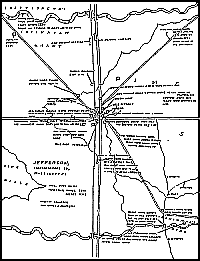 Yoknapatawpha
County Map: In his 1936 novel Absalom,
Absalom!, the sixth novel set in Yoknapatawpha
County, Faulkner included a hand-drawn map of his apocryphal county. In
the map's "key" he declares the geographical size of the county
(2,400 square miles) and its population (Whites, 6298; Negroes, 9313), and
he "signed" the map "William Faulkner, Sole Owner &
Proprietor." The map depicts how the general dimensions of the county
resemble those of his actual Lafayette County, Mississippi, with the Tallahatchie
River serving as the county's northern border and the Yoknapatawpha
River the southern boundary. The county seat of Jefferson
(in the same general area that Oxford
occupies in Lafayette County) lies in the dead center of the county, and is
the intersection of major roads to the north (towards "Memphis
Junction"), south (towards "Mottson"), east, and west, with
additional roads leading northwest toward Sutpen's
Hundred, northeast (towards the MacCallum
place), and southeast, where the hamlet of Frenchman's
Bend lies along the Yoknapatawpha River. The map is significant because
it depicts not just events from Absalom, Absalom! but also key places
from his earlier Yoknapatawpha novels. Later, Faulkner would publish another
updated map of the county with Malcolm Cowley's edition of The
Portable Faulkner, but this one remains the one most often referred
to as a geographic record of the county.
Yoknapatawpha
County Map: In his 1936 novel Absalom,
Absalom!, the sixth novel set in Yoknapatawpha
County, Faulkner included a hand-drawn map of his apocryphal county. In
the map's "key" he declares the geographical size of the county
(2,400 square miles) and its population (Whites, 6298; Negroes, 9313), and
he "signed" the map "William Faulkner, Sole Owner &
Proprietor." The map depicts how the general dimensions of the county
resemble those of his actual Lafayette County, Mississippi, with the Tallahatchie
River serving as the county's northern border and the Yoknapatawpha
River the southern boundary. The county seat of Jefferson
(in the same general area that Oxford
occupies in Lafayette County) lies in the dead center of the county, and is
the intersection of major roads to the north (towards "Memphis
Junction"), south (towards "Mottson"), east, and west, with
additional roads leading northwest toward Sutpen's
Hundred, northeast (towards the MacCallum
place), and southeast, where the hamlet of Frenchman's
Bend lies along the Yoknapatawpha River. The map is significant because
it depicts not just events from Absalom, Absalom! but also key places
from his earlier Yoknapatawpha novels. Later, Faulkner would publish another
updated map of the county with Malcolm Cowley's edition of The
Portable Faulkner, but this one remains the one most often referred
to as a geographic record of the county.
-
Yoknapatawpha River: The southern boundary of Yoknapatawpha County, and apparently based on the actual Yocona River in Lafayette County, Mississippi. ("Yocona" is a corruption of "Yoknapatawpha.") The hamlet of Frenchman's Bend is located along the river. According to The Hamlet, slaves from the first plantation in the area straightened a nearly ten-mile stretch of the river to prevent flooding. In As I Lay Dying, the river flooded, washing several bridges out, so Anse Bundren and his family were initially unable to cross the river as they were trying to transport the body of Addie Bundren to Jefferson for burial.


